

Amazon River
This image shows the Amazon River meandering through one of the most vital ecosystems in the world – the Amazon rainforest in South America.
This image has been processed in a way that shows water bodies, such as the Amazon River, in blue. The Amazon river begins its journey in the Andes and makes its way east through six South American countries before emptying into the Atlantic Ocean on the northeast coast of Brazil. The river has a length of around 6400 km – the equivalent of the distance from New York City to Rome.
The Amazon is considered the widest river in the world with a width of between 1.6 and 10 km, but expands during the wet season to around 50 km. With more than 1000 tributaries, the Amazon River is the largest drainage system in the world in terms of the volume of its flow and the area of its basin. As a consequence of its ever-changing flow, older riverbeds can be seen as thin lines around the main river at the top of the image.
One of its tributaries, the Javari River, or Yavari River, is visible as a thinner blue line weaving through the tropical rainforest. The river flows for 870 km, forming the border between Brazil and Peru, before joining the Amazon River.
In the image, cities and built-up areas are visible in cyan, for example the cities of Tabatinga and Leticia with two airports are easily identifiable in the far-right. The yellow and orange colours in the image show the surrounding Amazon forest.
As radar images provide data in a different way than a normal optical camera, the images are usually black and white when they are received. By using a technology that aligns the radar beams sent and received by the instrument in one orientation – either vertically or horizontally – the resulting data can be processed in a way that produces coloured images such as the one featured here. This technique allows for a better distinction of features on the ground.
ADDITIONAL TECHNICAL NOTES: The colours of this week’s image come from the combination of two polarisations from the Copernicus Sentinel-1 radar mission, which have been converted into a single image.

São Miguel, Azores
This image from over the Azores island of São Miguel features a volcanic complex called the Sete Cidades Massif.
The circular crater or caldera dominates the image and measures about 5 km across. The interior has lakes, volcanic cones, lava domes and maars – or shallow, flooded craters.
The Lagoa das Sete Cidades – or Lagoon of Seven Cities – is comprised of two ecologically different lakes that are connected by a narrow passage, visible at the centre of the image. The lake to the north is known as the Blue Lake while to the one to the south is the Green Lake for the colours they reflect.
According to the legend, the protected daughter of a king escaped to the surrounding hills, where she met and fell in love with a young shepherd. When the shepherd asked the king for his daughter in marriage, the king refused and forbade his daughter from seeing the boy again. The two met secretly one last time and cried until their tears filled the valleys to form the two lakes: one green as the Princess's eyes were green, and the other blue like the shepherd’s eyes.
In the surrounding area we can see the distinct lines where vegetation grows along waterways radiating from the circular massif. Between these lines are agricultural plots.
ADDITIONAL TECHNICAL NOTES: This image was acquired by the Spanish Deimos-2 satellite on 6 December 2014. With its high-resolution optical imager, the satellite can see down to a 75 cm ground resolution.
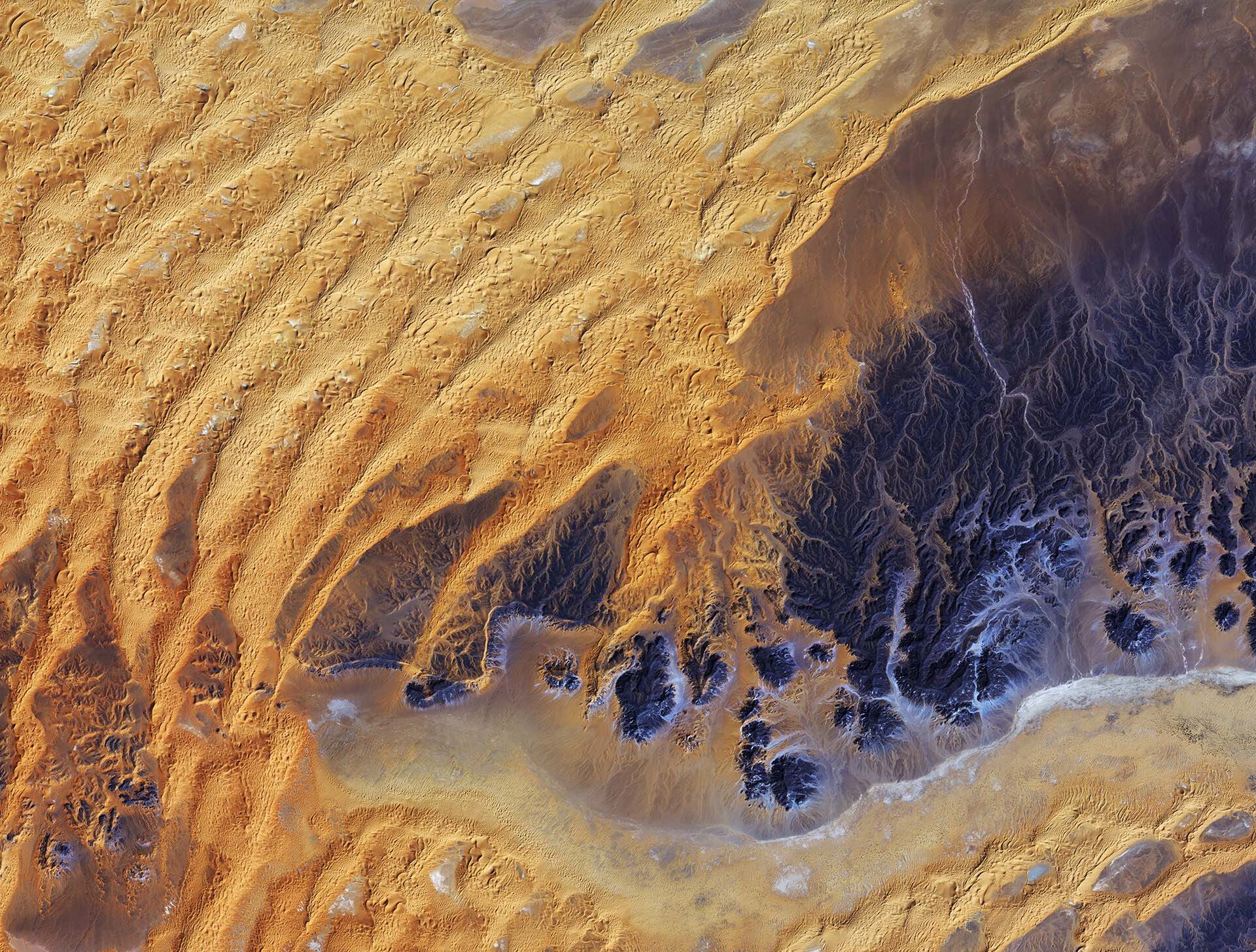
Saharan Desert, Algeria
This satellite image was captured over southeastern Algeria in the heart of the Sahara desert.
The heat and lack of water render vast desert areas highly unwelcoming, making satellites the best way to observe and monitor these environments on a large scale.
Satellites provide information on desert ecosystems and their expansion, and about areas at risk of soil degradation, erosion and desertification. Data from spaceborne sensors also assist in the water management of inhabited arid regions, and can track and help predict the movement of dust storms.
Optical imagery of deserts from space is arguably the most fascinating: the diversity and untouched state of these landscapes produce unique and striking scenes.
In this image, a large area of rock appearing purple stretches across the right side of the image, with fluvial erosion patterns testament to an earlier time when the area received more rainfall. Today, this area sees an average of about 10 mm of rainfall per year.
Wind-shaped sand dunes are visible on the left. The area at the bottom appears to be flat, with tiny specks of vegetation.
Just south of this image lies the Tassili n’Ajjer National Park and UNESCO World Heritage Site, renowned for its 10 000 year-old cave art. The drawings and engravings depict culture and the environment from a time when climatic conditions were more favourable to human occupation.
ADDITIONAL TECHNICAL NOTES: Japan’s ALOS satellite recorded this image on 28 January 2011.

Alberta, Canada
To the north, blue lake waters are visible, interspersed with rivers and creeks. This area makes up the world’s largest freshwater inland river delta, where the Peace and Athabasca rivers converge on the Slave River and Lake Athabasca (the water body in the upper right).
Lake Claire to the left is also part of this delta system, and lies within the Wood Buffalo National Park – Canada’s largest.
The lower half of the image is part of a wider area known as the Athabasca oil sands, which has the world’s largest known reservoir of crude bitumen, which can be upgraded to crude oil using technology that extracts the oil from the soil using chemicals.
Boreal forests and peat bogs in this area are being destroyed by open-pit mining. Boreal forests cover nearly half of the province, but about .2% has been disturbed by open-pit mining, some of which are visible in the lower-right. In addition to deforestation, these activities cause pollution and push wildlife from their preferred habitats.
ADDITIONAL TECHNICAL NOTES: This is a Landsat-8 image from 13 April 2014.

Kumbunbur Creek, Australia
This false-colour satellite image shows the Kumbunbur Creek in Australia’s Northern Territory, about 260 km southwest of the city of Darwin.
The image was acquired near the end of the dry season. The dry areas with a somewhat dull colour become flooded mudflats during the rainy season.
The green ‘branches’ of what looks like a tree are the waterways of runoff that flow into the Timor Sea (not pictured).
The false-colour makes vegetation appear bright red, and we can clearly see how vegetation grows mainly along the waterways. Vegetation is more evenly dispersed across the plain to the north.
The rainy season occurs during a tropical area’s summer months because of increased heat from the Sun’s more direct impact angle. Higher temperatures lead to an increase in evaporation and rising, warm air masses. This air expands and cools, leading to the formation of cumulus clouds, and almost daily rainfall and thunderstorms.
As seasons change, the location of these rainfalls travels to areas with the highest Sun impact angles, resulting in wet and dry seasons in different zones of the tropics.
ADDITIONAL TECHNICAL NOTES: The image was captured by the Kompsat-2 satellite on 20 September 2011.

Rub’ al Khali desert
Rolling sand dunes in the expansive Rub’ al Khali desert on the southern Arabian Peninsula are pictured in this radar image from the Sentinel-1A satellite.
Rub’ al Khali – also known at the ‘Empty Quarter’ – is part of the greater Arabian Desert. Its sand dunes reach up to 250 m in height and in some areas are interspersed with hardened flat plains, evident at this bottom half of this image. These plains are what is left of shallow lakes that existed thousands of years ago, formed by monsoon-like rains and runoff.
Today, the region is considered to be ‘hyper-arid’, with precipitation rarely exceeding 35 mm a year and regular high temperatures around 50°C.
Rub’ al Khali has experienced major desertification over the past 2000 years. Until about the year 300 AD, trade caravans crossed what is today an impassable wasteland.
In the upper part of this image, we can see a road snaking through the remote desert and leading to Kharkhir (not pictured), a Saudi village near the border with Yemen.
ADDITIONAL TECHNICAL NOTES: This is a radar image from the Sentinel-1A satellite from 2014.

Uluru/Ayers Rock — 'Island Mountain'
Under Australia’s dual naming policy, the formation is officially called by both the traditional Aboriginal name and the English name.
Uluru stands over 340 m above the surrounding desert and measures about 9 km around. In addition to being a geological wonder, it is a historical one as well: ancient rock art can be seen at points along the base of the formation. Many of these paintings were created by the elders of Aboriginal tribes to teach younger generations how to track and hunt animals – much like how a teacher uses a school blackboard.
The rock formation is an Inselberg – German for ‘island mountain’ – a prominent geological structure that rises from the surrounding plain.
Hundreds of millions of years ago, this part of Australia was a shallow sea. Layers of sandstone settled on the ocean floor and were compressed. These hardened, horizontal layers were uplifted and tilted almost 90º upwards to their present position. The rock eroded slower than the surrounding softer deposits until the monolith stood high above an otherwise flat surface.
From this perpendicular angle of the satellite acquisition, we can see those layers that were once horizontal and now appear to cut across the top of the formation.
This area in the southern part of the Northern Territory is home to a variety of animals, including the red kangaroo, dingo, hopping mouse, marsupial mole, various bats and over 70 species of reptiles.
ADDITIONAL TECHNICAL NOTES: The Korea Aerospace Research Institute’s Kompsat-2 satellite acquired this image on 15 September 2011.

Westfjords peninsula, Northwest Iceland
Located in the North Atlantic Ocean east of Greenland and immediately south of the Arctic Circle, Iceland is the westernmost European nation, and has more land covered by glaciers than the whole of continental Europe. The country sits on the mid-Atlantic Ridge, where two tectonic plates are moving away from each other, causing strong geothermal and volcanic activity.
The grey area that is somewhat shaped like a Christmas tree is land, while the colourful spaces between the 'branches' are long fjords – long, narrow arms of the sea that stretch far inland.
During the ice ages both ice and rivers carved deep valleys in the mountains. As the climate changed, most of the ice melted, and the valleys were gradually filled with salt water from the coast, giving birth to the fjords.
The white dots along one of the fjords close to the centre of the image are radar reflections from Westfjords peninsula’s largest town, Ísafjörður. More radar reflections from other towns can also be seen scattered along the coastline.
ADDITIONAL TECHNICAL NOTES: This image was created by combining three Envisat radar acquisitions from 11 September 2004, 14 April 2007 and 3 May 2008 over the same area.

THE EUROPEAN SPACE AGENCY (ESA) is an intergovernmental organization based in Paris of 22 member states dedicated to the exploration of space, with the purpose of "providing for, and promoting, for exclusively peaceful purposes, cooperation among European States in space research and technology and their space applications."
WHITNEY SMITH is the Publisher and Editor of The Journal of Wild Culture. He lives in Toronto.
Add new comment